Southern · Thailand
Ranong · ระนอง
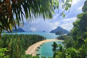
Hot springs, Koh Phayam boho island, Myanmar border crossing by boat.
- Region
- Southern
- Population
- 200,000
- Area
- 3,298 km²
- Stories filed
- 1
About Ranong
History
Ranong was a major tin-mining town in the nineteenth century, its mining rights held by the Koh family of Hokkien Chinese merchants from Penang — a clan-house at Nai Khai Ranong now operates as a museum. The province has the longest land border with Myanmar of any Thai province and has served as an overland back-channel for traders, migrants, and the occasional political dissident since the colonial era. The Kawthaung crossing opposite Ranong town is one of Southeast Asia's most actively used visa-run border points.
Landscape & geography
Narrow, densely forested, and extremely wet — Ranong regularly records Thailand's highest annual rainfall at over 4,000 millimetres, fed by moisture-laden southwest monsoon winds hitting the Tenasserim range. The province is a thin strip of coastal lowland and mangrove estuary pinned between the mountains and the Andaman. Laem Son National Park protects the longest undeveloped Andaman coastline in Thailand; the Kra River, proposed as the route of a trans-isthmus canal, drains the province's central valley into the Andaman at Ranong town.
Why visit
Raksawarin Public Park's geothermal hot springs — 65°C at source, cooled to 40°C in the public pools — are the most developed natural hot-spring complex in southern Thailand, open daily. Koh Phayam's beaches, reached by an hour-long ferry from Ranong pier, offer car-free island life, cashew orchards, and some of the Andaman's better budget bungalow culture. Laem Son's deserted mainland beaches are accessible by kayak through the mangroves. The morning Kawthaung boat-taxi to Myanmar provides a taste of the Tanintharyi coast. Ranong is a quieter, wetter, and more character-rich alternative to Phuket.
Stories from Ranong
Articles, reviews, and itineraries tagged to this province.