Northeastern · Thailand
Mukdahan · มุกดาหาร
Indo-China market, Mekong border to Laos, Phu Pha Thoep canyon.
- Region
- Northeastern
- Population
- 352,000
- Area
- 4,340 km²
- Stories filed
- 1
About Mukdahan
History
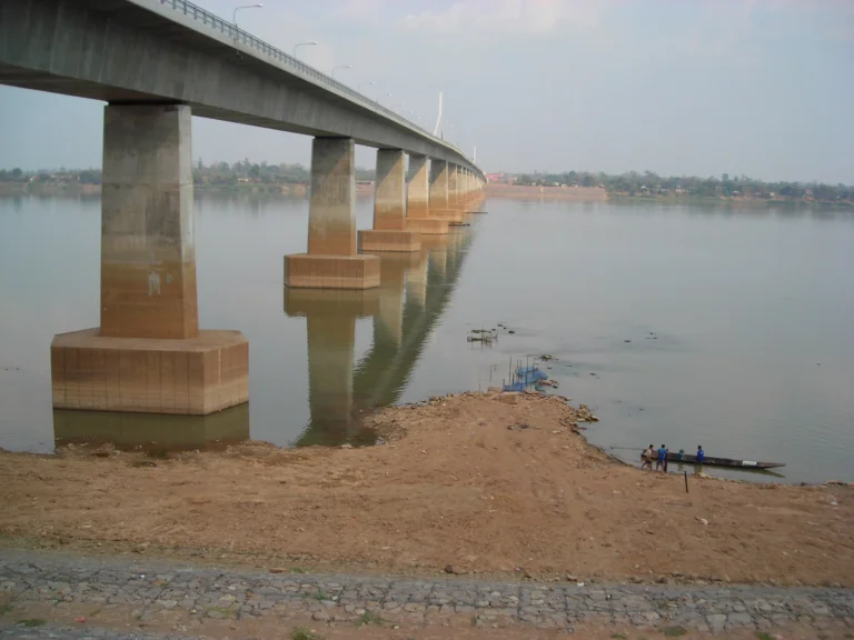
Mukdahan was carved from Nakhon Phanom in 1982 and has been defined twice over by its Mekong geography: first as a river-trade town facing the Lao city of Savannakhet across a narrow stretch of water, then as a logistics node after the Second Thai–Lao Friendship Bridge opened in 2007, connecting Thailand to the East–West Economic Corridor all the way to Vietnam. The province has always been more crossroads than destination — a place where Vietnamese, Lao, and Thai traders converge on weekends, and where goods from three countries stack up in the covered arcades of the Indochina Market.
Landscape & geography
The provincial skyline is anchored by two very different landmarks: the glass-mosaic exterior of Wat SriMongkol Klang, whose entire outer surface is tiled in tiny coloured mirrors and catches the sun like a beacon, and the sandstone mushroom formations of Phu Pha Thoep National Park just outside town. The Mekong forms the eastern border — wide, brown, and crossed by long-tail ferries — while forested hills rise to the west through Phu Phia National Park, where cool-season mornings bring fog to the plateau trails and seasonal wildflowers to the ridges.
Why visit
The main reason to come is the Indochina Market, a weekend institution where Lao imports, Vietnamese dry goods, and street-food vendors fill an open-air arcade beside the river — arrive early on Saturday morning for the freshest produce and the most animated crowd. Wat SriMongkol Klang is a quick but memorable add-on, and Phu Pha Thoep's rock garden is an easy half-day. Mukdahan works best as a one- or two-night stop on a wider Isan or Mekong loop: cross into Savannakhet for a day, then carry on north toward Nakhon Phanom or south to Ubon Ratchathani.
Stories from Mukdahan
Articles, reviews, and itineraries tagged to this province.